
Answer to Map #41
Click here for a full-size version of this week’s map.
Back to this week’s maps and hints.
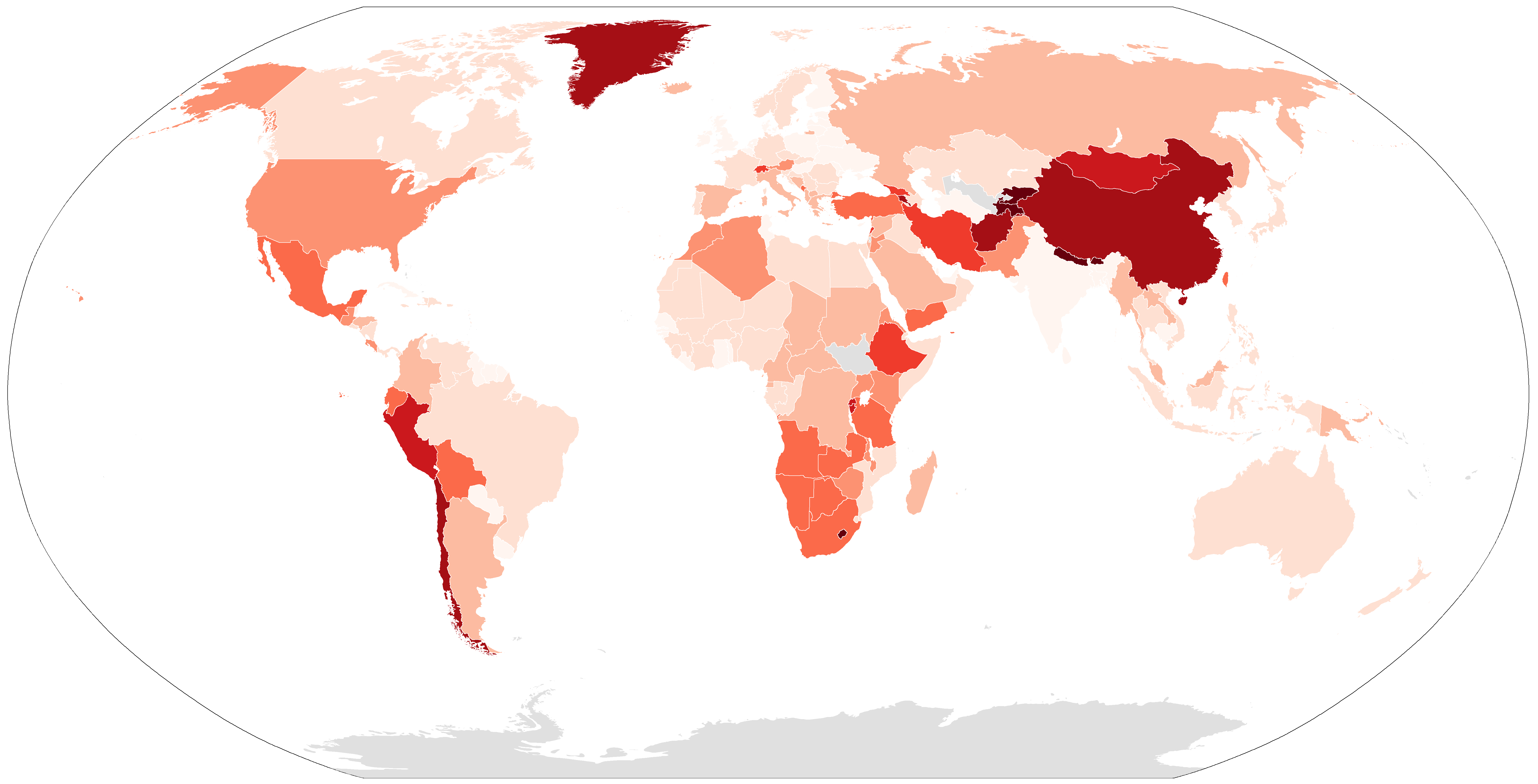
Answer: This week’s map was a choropleth in which the countries of the world were shaded according to their average elevations.
The data used to make this map came from the CIA World Factbook. For some reason, the CIA hasn’t bothered to figure out the average elevation of Uzbekistan.
The countries with the highest elevations are Bhutan (10,761 feet), Nepal (10,712 feet), Tajikistan (10,453 feet), and Kyrgyzstan (9,803 feet). These countries all contain some of the highest mountain ranges in the world, including the Himalayas, the Pamirs, and the Tian Shan. Of the countries for which we have data, the one with the lowest average elevation is the Maldives, a country consisting of coral atolls in the Indian Ocean, which has an average elevation of only six feet. As a low-lying country, the Maldives will face a dire situation as the polar ice caps continue to melt and sea levels rise.
For this map, we have chosen a linear scale. The six countries with the darkest color are all over 6,500 feet in average elevation. The next darkest color indicates countries over 5,688 feet in average elevation. The third darkest color is for countries over 4,876 feet in average elevation. And so on.
It’s important not to confuse a country’s average elevation, which takes into account the elevations of all parts of the country, with how much of the country is covered by mountains. (We did give half credit for the latter answer in the student category, but not in the non-student category) Take a look at China and India, both of which have territory high in the Himalayas. China is much darker on this map because of the Tibetan Plateau: large swaths of China have elevations over 11,000 feet. In general, a country gets darker on this map when it has large areas with mid-range elevations, rather than when it has a few mountains that are extremely tall.
One interesting feature of this map is the striking difference between Armenia and Azerbaijan. Armenia is relatively high (5,879 feet), while Azerbaijan is much lower (1,260 feet). One reason for this disparity is that Armenia has somewhat more of the Caucasus Mountains than does its neighbor. But its also worth noting that the Caspian Sea, which borders Azerbaijan, is very low. Baku, the capital of Azerbaijan, is 92 feet below sea level. It has the distinction of being the world’s most populous city below sea level.
Another low-lying country is the Netherlands (98 feet). Of all the non-island countries on our map, the only one that has a lower average elevation is Qatar (92 feet). Much of the Netherlands occupies land that has been re-claimed from the sea. The Dutch have been building dikes and pumping out seawater to create farmland for centuries.
Next map: Click here to try out our newest map question.
